Military map of south-eastern Virginia
View
@ Lionel Pincus and Princess Firyal Map Division. The New York Public Library

Krebs, Charles G Lindenkohl, H. (Henry)
Description
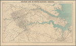
Shows 5-mile concentric circles centered on Richmond, roads, bridges, railroads, towns, houses, drainage, vegetation, and some fortifications in the Richmond-Petersburg area. Relief shown by hachures. Depths shown by soundings. Oriented with north toward upper left. Includes list of compilation sources ; last entry on list of authorities under title area: "Campaign maps, Army of the Potomac / by Genl. G. Weitzel, 1864. Information received from Engineer Department." Bay and principal rivers green. Title appears outside of the top border.
Text
Maps
United States Coast SurveyLindenkohl, A
1864


