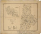
Map of Durham County, North Carolina (E. M. Eastwood)
View
@ University of North Carolina at Chapel Hill
Eastwood, E. M Wells and Brinkley
Description
Map shows townships, schools, African American schools, churches, cotton gins, retail stores, school districts, cemeteries, mills, county homes, and railroads, including the Southern Railway, Durham and Southern Rail Road, and Norfolk and Western Railroad. Township square miles and estimated population for 1920 reported in margin. Inset map shows "Cities of Durham, East and West Durham. Scale 4" = 1 Mile." Townships shown include Carr, Cedar Fork, Durham, Lebanon, Mangum, Oak Grove, and Patterson.
Image
Maps
This item is presented courtesy of the State Archives of North Carolina, for research and educational purposes. Prior permission from the State Archives is required for any commercial use.


