
Wells & Brinkley Engineers
Description
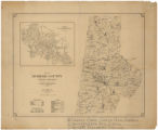
Shows cities and towns, roads, school districts, African American schools and white schools. Includes inset map of Durham, East Durham, and West Durham. Provides tables showing the estimated population of the county by race and the area of townships in square miles.
Image
Maps
Public domain
Record Contributed By
University of North Carolina at Chapel HillRecord Harvested From
North Carolina Digital Heritage CenterKeywords
Related Content
")


, 1978-1982")


 Board of Commissioners, Feb. 12-April 5, 1982")
 Board of Commissioners, Jan. 4-Feb. 2, 1983")
 meeting.")

 Board of Commissioners, Aug. 13-Sept. 1982")


 Board of Commissioners, June 9-20, 1982")


